Char Dham Highway Expansion: Is Uttarakhand at Greater Risk of Disasters?
Introduction
Every monsoon, the roads in Uttarakhand tell a story. Slopes collapse without warning. Traffic halts for hours. News alerts report fresh landslides along newly widened stretches of mountain highways.
When the mountains fall silent, people assume they are stable. But the Himalayas are young, restless, and fragile. In recent years, Uttarakhand has witnessed repeated landslides, flash floods, road collapses, and even sinking towns.
In the middle of this sensitive terrain stands one of India’s most ambitious infrastructure projects — the Char Dham Highway expansion. Designed to improve connectivity to Yamunotri, Gangotri, Kedarnath, and Badrinath, the project promises safer roads, faster travel, and economic growth through tourism.
But in a state already prone to floods and landslides, a deeper question is emerging: is faster connectivity quietly increasing disaster risk?
To answer that, we need to look beyond asphalt and ambition — and into the geology of the Himalayas.
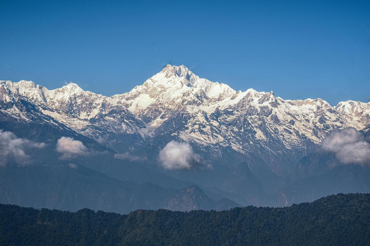
The Geological Fragility of the Himalayas
The Himalayas are not like the plains. They are geologically young mountains, still rising, still shifting. The rocks are fractured. Slopes are steep. Rivers are aggressive. Heavy rainfall can destabilize entire hillsides within hours.
Uttarakhand, in particular, sits in a high seismic zone. It is prone to landslides, flash floods, cloudbursts, and earthquakes. When large-scale construction begins in such terrain, the risks multiply.
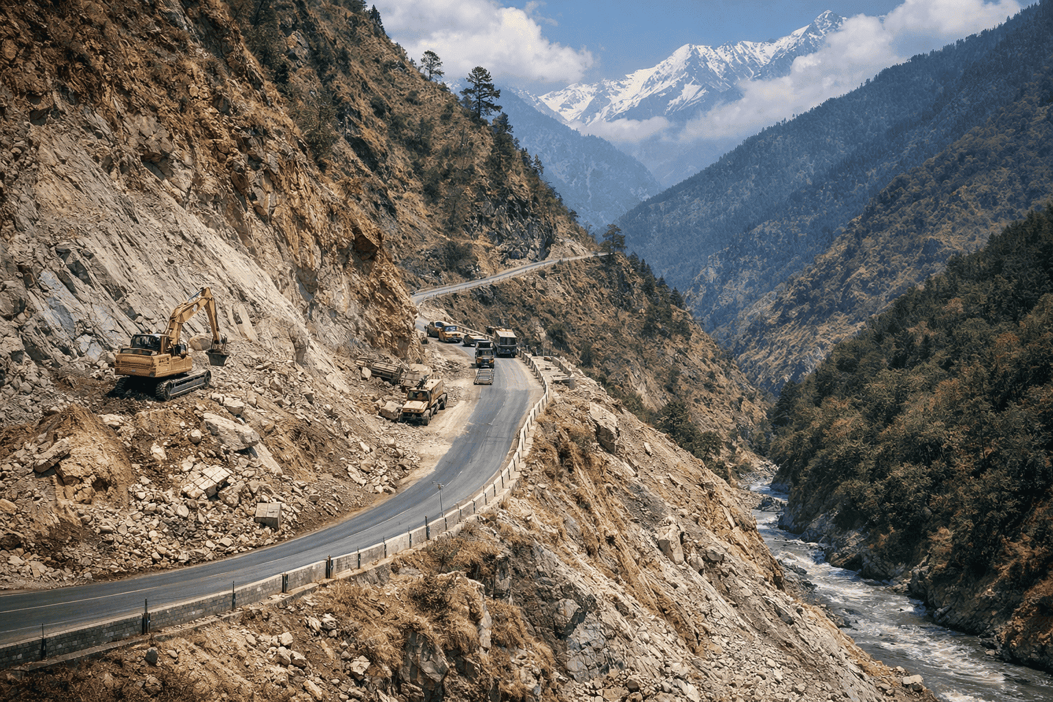
Road widening often involves cutting into hillsides. Trees are removed. Slopes are blasted. Debris is dumped along riverbanks. These changes may look manageable during dry months, but during monsoon season, they can trigger slope failures and block rivers — increasing flood risk downstream.
Infrastructure in fragile terrain is not automatically wrong. But it must respect ecological limits. The question is whether this balance is being maintained.
Lessons from Kedarnath That Still Echo
In 2013, catastrophic floods struck the region around Kedarnath. Thousands lost their lives. Entire settlements were swept away. The disaster was triggered by extreme rainfall, glacial lake overflow, and sudden flooding of the Mandakini River.
But natural rainfall alone was not the whole story.
Unregulated construction, hotels built too close to riverbanks, poorly planned roads, and debris dumping worsened the damage. Development had ignored ecological warning signs.
After Kedarnath, many expected a shift in how mountain infrastructure would be designed. There was talk of carrying capacity, stricter environmental impact assessments, and better slope stabilization.
A decade later, critics argue that some of those lessons are being tested again.
A decade later, critics argue that some of those lessons are being tested again. Many of the concerns around the Char Dham Highway echo the lessons from the 2013 Kedarnath disaster, when unregulated construction amplified the impact of extreme rainfall and weak environmental oversight.
Road Widening and Landslide Risk
One of the most visible aspects of the Char Dham project is extensive hill cutting to widen roads. While wider roads improve traffic flow and allow easier movement for pilgrims and defense vehicles, the method of expansion matters.
When slopes are cut steeply without adequate reinforcement, they become unstable. During heavy rain, loose soil and fractured rock slide down easily. In recent monsoons, multiple stretches of newly widened roads have reported landslides.
Experts point out that the Himalayas require slope-sensitive engineering — not just blasting and cutting. Retaining walls, proper drainage, vegetation restoration, and controlled debris disposal are crucial.
If these safeguards are weak or rushed, the highway could unintentionally increase disaster vulnerability.
Tourism Growth and Carrying Capacity in Uttarakhand
Tourism is the backbone of Uttarakhand’s economy. Improved connectivity means more pilgrims, more hotels, more vehicles, and more economic activity.
But there is another side to this growth.
More visitors mean more pressure on local ecosystems — waste generation, water demand, construction along rivers, and traffic congestion in fragile valleys. If tourist numbers exceed what the region can safely support, disaster risk rises.
This is where the concept of carrying capacity becomes important. Every ecosystem has limits. When those limits are ignored, natural buffers weaken.
The real challenge is not whether development should happen — it’s whether it happens within ecological limits.
Joshimath and the Warning Signs for Mountain Infrastructure
In 2023, cracks appeared in homes and roads in the town of Joshimath. Gradually, the land beneath parts of the town began to sink. Residents were evacuated. Images of tilted buildings spread across the country.
While land subsidence has multiple causes — including geology, water seepage, and past construction — the incident intensified concerns about large-scale development in fragile mountain zones.
Joshimath became a reminder that the Himalayas cannot absorb unlimited infrastructure stress.
The highway project passes through several ecologically sensitive zones. The debate is not about stopping connectivity — it’s about ensuring that infrastructure does not outpace geological reality.
Climate Change and Rising Disaster Risk in the Himalayas
There’s another factor that makes this discussion urgent: climate change.
The Himalayas are warming faster than many other regions. Glaciers are retreating. Extreme rainfall events are becoming more frequent. Cloudbursts are more intense.
When heavy rainfall hits freshly cut slopes, the probability of landslides increases. When rivers are blocked by debris, sudden floods become more likely.
Infrastructure built for yesterday’s climate may not be resilient enough for tomorrow’s.
So the real question becomes: Is the Char Dham Highway designed for future climate conditions — or past ones?
Recent studies on climate change in the Himalayas show that extreme rainfall events are becoming more frequent, raising concerns about how resilient new infrastructure really is.
Development vs. Safety: Is It a False Choice?
Supporters of the highway argue that better roads reduce accident risk and improve disaster response times. Wider roads allow emergency vehicles and military convoys to move quickly. They also reduce traffic jams that trap vehicles in landslide-prone zones.
These are valid arguments.
The issue is not whether roads should exist. It is about how they are built.
Are environmental impact assessments being fully implemented?
Is debris disposal monitored strictly?
Are slope stabilization measures scientifically planned?
Are river ecosystems protected?
If safeguards are strong, development can coexist with safety. If shortcuts are taken, risks increase.
What Responsible Mountain Development Looks Like
If Uttarakhand wants both growth and safety, a few principles are essential:
1. Slope-Sensitive Engineering
Blasting should be minimized. Hill cutting must follow geological surveys. Natural drainage patterns must be preserved.
2. Strict Debris Management
Construction waste should not be dumped into rivers or down slopes. Controlled disposal reduces flood risk.
3. Carrying Capacity Limits
Pilgrim and tourist numbers should align with what local infrastructure can handle.
4. Transparent Monitoring
Independent audits and public data on slope stability and environmental compliance build trust.
5. Climate-Resilient Planning
Road design must account for extreme rainfall, not average rainfall.
Development in the Himalayas requires humility. These mountains are not static landscapes — they are dynamic systems.
Is Uttarakhand Becoming More Vulnerable?
So, is the Char Dham Highway making Uttarakhand more vulnerable to disasters?
The honest answer is nuanced.
The project itself is not inherently dangerous. Connectivity, economic opportunity, and improved infrastructure are important for the region. But vulnerability increases when ecological sensitivity is underestimated.
If construction ignores geological fragility, landslide frequency could rise. If tourism expands without limits, environmental stress will grow. If climate risks are not integrated into planning, future disasters could be more severe.
The highway is not just a road. It is a test of how India approaches development in fragile landscapes.
A Choice That Shapes the Future
Uttarakhand stands at a crossroads.
It can pursue growth that respects ecological boundaries — or growth that stretches them too far.
The 2013 floods, recurring landslides, and sinking towns are not isolated events. They are signals. The Himalayas respond quickly when pushed beyond capacity.
The goal should not be to halt development. It should be to redesign it — in a way that aligns with the realities of mountain ecosystems.
Because in the Himalayas, vulnerability is not created overnight. It builds slowly, through small compromises that add up.
If the Char Dham Highway becomes a model for climate-aware, geology-sensitive infrastructure, it could strengthen Uttarakhand’s future.
If not, the costs may be measured not just in repair budgets — but in human lives.
Final Thought
The debate around the Char Dham Highway is bigger than one project. It reflects a larger question facing mountain regions across India:
Can development respect natural limits?
Uttarakhand’s future depends on that answer.
And the Himalayas are watching.
Frequently Asked Questions
1. What is the Char Dham Highway project?
The Char Dham Highway project is a road expansion initiative in Uttarakhand aimed at improving connectivity to the four major pilgrimage sites — Yamunotri, Gangotri, Kedarnath, and Badrinath. The goal is to make travel safer and faster, especially during the peak pilgrimage season. The project includes road widening, slope cutting, and infrastructure upgrades across several mountainous districts.
2. Why is the Char Dham Highway controversial?
The controversy is mainly about environmental and geological concerns. Critics argue that large-scale hill cutting and road widening in fragile Himalayan terrain could increase landslides and flood risk. Supporters say better roads improve safety and disaster response. The debate centers on whether development is happening with enough ecological safeguards.
3. Can road widening increase landslide risk in Uttarakhand?
It can — especially if slopes are cut too steeply or debris is not properly managed. The Himalayas are naturally unstable due to their young geology. When hillsides are disturbed without adequate reinforcement, heavy rainfall can trigger landslides more easily. Proper engineering and drainage systems are crucial in reducing this risk.
4. How is climate change affecting disaster risk in the Himalayas?
Climate change is increasing the frequency of extreme rainfall events in the Himalayan region. Intense downpours, cloudbursts, and glacial melt can all raise the chances of floods and landslides. When infrastructure is built in vulnerable zones without accounting for these changing patterns, disaster risks may grow over time.
5. Is development in Uttarakhand possible without increasing disaster risk?
Yes — but it requires careful planning. Development in mountain states must follow slope-sensitive engineering, strict environmental monitoring, and limits on tourism growth. The challenge is not whether development should happen, but how it is carried out in fragile ecosystems like the Himalayas.
Related Articles
Why Himadri is the Highest Himalayan Range (Explained in a Simple Way)
Why is Himadri higher than other Himalayan ranges? Discover the simple reasons behind its height with an easy, beginner-friendly explanation.
Climate Change Impact on Himalayan Rivers
Climate change is rapidly affecting Himalayan rivers like the Ganges, Brahmaputra, and Indus. Learn how glacier melting, changing rainfall, and floods threaten water security for nearly 2 billion people.
Why Himalayan Glaciers Are Melting Faster Than Ever — And Why the World Should Care
Himalayan glaciers are melting faster than ever. Discover the real causes, scientific warnings, and what glacier loss means for rivers, communities, and climate.